Login
Register


SHD
Shenandoah Valley Regional Airport
Official FAA Data Effective 2026-01-22 0901Z
Chart Supplement

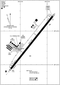
KSHD Airport Diagram
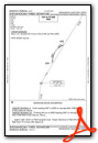
VFR Chart of KSHD
Sectional Charts at SkyVector.com
IFR Chart of KSHD
Enroute Charts at SkyVector.com
Location Information for KSHD
Coordinates: N38°15.83' / W78°53.79'Located 10 miles NE of Staunton/Waynesboro/Harrisonburg, Virginia on 433 acres of land. View all Airports in Virginia.
Surveyed Elevation is 1201 feet MSL.
TPA 800 FT PISTON ACFT, 1500 FT JET/TURBO ACFT.
Operations Data
|
|
Airport Communications
| AWOS-3: | 124.925 Tel. 540-234-0110 |
|---|---|
| POTOMAC APPROACH: | 132.85 323.125 |
| POTOMAC DEPARTURE: | 132.85 323.125 |
| CLEARANCE DELIVERY: | 118.35 |
| CTAF: | 123.000 |
| UNICOM: | 123.000 |
| AWOS-3 at VBW (6.9 NW): | 119.55 540-828-2076 |
| AWOS-3PT at W13 (11.3 S): | 118.625 540-941-7570 |
| ASOS at CHO (22.2 E): | 434-975-0110 |
- COMMUNICATIONS PRVDD BY LEESBURG RADIO 122.1R/115.3T (MONTEBELLO RCO).
Nearby Navigation Aids
|
| ||||||||||||||||||||||||||||||||||||||||||||||||||||||||||||


Runway 05/23
| Dimensions: | 6002 x 150 feet / 1829 x 46 meters | |
|---|---|---|
| Surface: | Asphalt / Grooved in Good Condition | |
| Weight Limits: | S-75, D-150, ST-215
PCR VALUE: 554/F/B/X/T
| |
| Edge Lighting: | High Intensity | |
| Runway 05 | Runway 23 | |
| Coordinates: | N38°15.44' / W78°54.17' | N38°16.22' / W78°53.40' |
| Elevation: | 1174.3 | 1200.9 |
| Traffic Pattern: | Left | Left |
| Runway Heading: | 38° True | 218° True |
| Declared Distances: | TORA:6002 TODA:6002 ASDA:6002 LDA:6002 | TORA:6002 TODA:6002 ASDA:6002 LDA:6002 |
| Markings: | Precision Instrument in good condition. | Non-Precision Instrument in good condition. |
| Glide Slope Indicator | P4L (3.00° Glide Path Angle) | P4L (3.00° Glide Path Angle) |
| Approach Lights: | MALSR 1,400 Foot Medium-intensity Approach Lighting System with runway alignment indicator lights. | |
| REIL: | Yes | |
| Obstacles: | 59 ft Pole 2500 ft from runway, 300 ft left of center | |
Services Available
| Fuel: | 100LL (blue), Jet-A |
|---|---|
| Transient Storage: | Hangars,Tiedowns |
| Airframe Repair: | MAJOR |
| Engine Repair: | MAJOR |
| Bottled Oxygen: | HIGH/LOW |
| Bulk Oxygen: | NONE |
| Other Services: | CROP DUSTING SERVICES,CARGO HANDLING SERVICES,PILOT INSTRUCTION,AIRCRAFT RENTAL |
Ownership Information
| Ownership: | Publicly owned | |
|---|---|---|
| Owner: | SHENANDOAH VAL REG ARPT COMM | |
| 77 AVIATION CIR. | ||
| WEYERS CAVE, VA 24486 | ||
| 540-234-8304 | ||
| Manager: | LISA BOTKIN | |
| 77 AVIATION CIR. | ||
| WEYERS CAVE, VA 24486 | ||
| 540-234-8304 | ||
Other Remarks
- FOR CD CTC POTOMAC APCH AT 866-640-4124.
- ACTVT MALSR RWY 05; REIL RWY 23; HIRL RWY 05/23 & TWY LGTS - CTAF. PAPI RWY 05 & 23 OPRS CONSLY.
- TPA 800 FT PISTON ACFT, 1500 FT JET/TURBO ACFT.
Weather Minimums

Instrument Approach Procedure (IAP) Charts

Departure Procedure (DP) Charts
Nearby Airports with Instrument Procedures
| ID | Name | Heading / Distance | ||
|---|---|---|---|---|
 |
KVBW | Bridgewater Air Park Airport | 334° | 6.8 |
|
W13 | Eagle's Nest Airport | 191° | 11.4 |
|
KCHO | Charlottesville-Albemarle Airport | 109° | 22.3 |
|
8W2 | New Market Airport | 020° | 25.1 |
|
KLUA | Luray Caverns Airport | 037° | 30.5 |
|
KGVE | Gordonsville Municipal Airport | 100° | 35.2 |
|
KOMH | Orange County Airport | 091° | 40.2 |
|
W99 | Grant County Airport | 345° | 45.4 |
|
KLKU | Louisa County/Freeman Field Airport | 108° | 46.4 |
|
KHSP | Ingalls Field Airport | 247° | 48.2 |
|
KFRR | Front Royal-Warren County Airport | 037° | 49.5 |
|
KCJR | Culpeper Regional Airport | 071° | 51.4 |


