Login
Register
MOT
Minot International Airport
Official FAA Data Effective 2024-11-28 0901Z
VFR Chart of KMOT
Sectional Charts at SkyVector.com
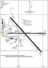
IFR Chart of KMOT
Enroute Charts at SkyVector.com
Location Information for KMOT
Coordinates: N48°15.46' / W101°16.68'Located 02 miles N of Minot, North Dakota on 1563 acres of land. View all Airports in North Dakota.
Surveyed Elevation is 1715 feet MSL.
Operations Data
|
|
Airport Communications
| ASOS: | 118.725 Tel. 701-837-9379 |
|---|---|
| MAGIC CITY TOWER: | 118.2 251.125 |
| MAGIC CITY GROUND: | 121.9 |
| MINOT APPROACH: | 119.6 363.8 |
| MINOT DEPARTURE: | 119.6 259.1 |
| UNICOM: | 122.950 |
| CTAF: | 118.200 |
| ASOS at MIB (9.3 N): | |
| ATIS at MIB (10.0 N): | 278.8 |
| AWOS-3 at 08D (45.1 W): | 121.1 701-628-1737 |
- APCH/DEP SVC PRVDD BY MINNEAPOLIS ARTCC ON FREQS 127.6/279.6 (MINOT RCAG) WHEN MINOT APCH CTL CLSD.
Nearby Navigation Aids
|
| ||||||||||||||||||||||||
Runway 13/31
| Dimensions: | 7700 x 150 feet / 2347 x 46 meters | |
|---|---|---|
| Surface: | Concrete / Grooved in Good Condition | |
| Weight Limits: | S-120, D-162, ST-262
PCR/500/R/C/W/T.
| |
| Edge Lighting: | High Intensity | |
| Runway 13 | Runway 31 | |
| Coordinates: | N48°15.91' / W101°17.32' | N48°14.97' / W101°16.07' |
| Elevation: | 1701.8 | 1657.1 |
| Traffic Pattern: | Left | Left |
| Runway Heading: | 138° True | 318° True |
| Declared Distances: | TORA:7700 TODA:7700 ASDA:7700 LDA:7700 | TORA:7700 TODA:7700 ASDA:7700 LDA:7700 |
| Markings: | Precision Instrument in good condition. | Precision Instrument in good condition. |
| Glide Slope Indicator | P4L (3.00° Glide Path Angle) | |
| RVR Equipment | Rollout | Touchdown |
| Approach Lights: | MALSR 1,400 Foot Medium-intensity Approach Lighting System with runway alignment indicator lights. | |
| REIL: | Yes | |
Runway 08/26
| Dimensions: | 6348 x 100 feet / 1935 x 30 meters | |
|---|---|---|
| Surface: | Asphalt / Grooved in Fair Condition | |
| Weight Limits: | S-81, D-118, ST-186
PCR/320/F/C/X/T.
| |
| Edge Lighting: | High Intensity | |
| Runway 08 | Runway 26 | |
| Coordinates: | N48°15.48' / W101°17.45' | N48°15.48' / W101°15.88' |
| Elevation: | 1715.7 | 1658.2 |
| Traffic Pattern: | Left | Left |
| Runway Heading: | 90° True | 270° True |
| Displaced Threshold: | 393 Feet | |
| Declared Distances: | TORA:6348 TODA:6348 ASDA:6348 LDA:5958 | TORA:5958 TODA:5958 ASDA:6348 LDA:6348 |
| Markings: | Non-Precision Instrument in good condition. | Non-Precision Instrument in good condition. |
| Glide Slope Indicator | P4L (3.00° Glide Path Angle) | P4L (3.00° Glide Path Angle) |
| REIL: | Yes | Yes |
| Obstacles: | 57 ft Trees 1900 ft from runway, 160 ft left of center RWY 08 APCH RATIO 24:1 FM DSPLCD THLD. |
|
Services Available
| Fuel: | 100LL (blue), Jet-A |
|---|---|
| Transient Storage: | Tiedowns |
| Airframe Repair: | MAJOR |
| Engine Repair: | MAJOR |
| Bottled Oxygen: | HIGH |
| Bulk Oxygen: | NOT AVAILABLE |
| Other Services: | CROP DUSTING SERVICES,AIR AMBULANCE SERVICES,AVIONICS,CHARTER SERVICE,PILOT INSTRUCTION,AIRCRAFT RENTAL,AIRCRAFT SALES |
Ownership Information
| Ownership: | Publicly owned | |
|---|---|---|
| Owner: | CITY OF MINOT | |
| 305 AIRPORT RD., SUITE 216 | ||
| MINOT, ND 58703 | ||
| 701-857-4724 | ||
| Manager: | JENNIFER ECKMAN | |
| 305 AIRPORT RD, SUITE 216 | ||
| MINOT, ND 58703 | ||
| 701-857-4724 | ||
Other Remarks
- DEER & BIRDS INVOF ARPT.
- TWYS E, B2, F, AND A ARE MKD WITH EDGE REFLECTORS.
- CUSTOMS SVC AVBL 24 HRS; FOR CUSTOMS CALL 701-838-6704.
- MINOT AFB (MIB) ASR OTS FOR PREVENTIVE MAINTENANCE FRIDAYS 0700-0900 & ALTN TUESDAYS 0630-0830.
- RDO EQUIPD ACFT MUST ANNC ON CTAF - 118.2 WHEN TWR IS CLSD.
- FOR CD IF UNA TO CTC ON FSS FREQ, CTC MINNEAPOLIS ARTCC AT 651-463-5588.
- WHEN ATCT IS CLSD, ACTVT MALSR RWY 31; REIL RWYS 08 & 26; HIRL RWYS 08/26 & 13/31 - CTAF. PAPI RWYS 08, 13, & 26 OPR CONSLY.
Weather Minimums
Instrument Approach Procedure (IAP) Charts
Nearby Airports with Instrument Procedures
| ID | Name | Heading / Distance | ||
|---|---|---|---|---|
 |
KMIB | Minot AFB Airport | 341° | 10.0 |
 |
KHBC | Mohall Municipal Airport | 341° | 32.4 |
 |
D05 | Garrison Municipal Airport | 190° | 36.7 |
 |
7K5 | Kenmare Municipal Airport | 308° | 39.4 |
 |
08D | Stanley Municipal Airport | 273° | 45.3 |
 |
D09 | Bottineau Municipal Airport | 044° | 48.6 |
 |
KRUG | Rugby Municipal Airport | 080° | 50.8 |
 |
05D | New Town Municipal Airport | 250° | 51.3 |
 |
KHZE | Mercer County Regional Airport | 192° | 59.4 |
 |
5H4 | Harvey Municipal Airport | 116° | 61.0 |
 |
D60 | Tioga Municipal Airport | 277° | 65.3 |
 |
06D | Rolla Municipal/Leonard Krech Field Airport | 059° | 76.0 |


Comments
Magnetic variation from 17
Magnetic variation from 17 Sept 2015 - 31 Mar 2016 7 E
Pages