Login
Register


FHB
Fernandina Beach Municipal Airport
Official FAA Data Effective 2025-03-20 0901Z
Chart Supplement

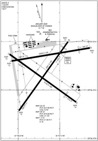
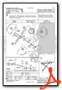
KFHB Airport Diagram
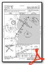
VFR Chart of KFHB
Sectional Charts at SkyVector.com
IFR Chart of KFHB
Enroute Charts at SkyVector.com
Location Information for KFHB
Coordinates: N30°36.71' / W81°27.67'Located 03 miles S of Fernandina Beach, Florida on 848 acres of land. View all Airports in Florida.
Surveyed Elevation is 15 feet MSL.
Operations Data
|
|
Airport Communications
| AWOS-3: | 118.075 Tel. 904-277-7323 |
|---|---|
| JACKSONVILLE APPROACH: | 127.0 292.15 |
| JACKSONVILLE DEPARTURE: | 127.0 292.15 |
| UNICOM: | 122.700 |
| CTAF: | 122.700 |
| ATIS at NRB (13.4 S): | 236.775 |
| D-ATIS at JAX (13.7 SW): | 125.85 |
| ASOS at JAX (13.9 SW): | 125.85 904-741-4304 |
Nearby Navigation Aids
|
| ||||||||||||||||||||||||||||||||||||||||||||||||||||||||||||


Runway 04/22
| Dimensions: | 5301 x 100 feet / 1616 x 30 meters | |
|---|---|---|
| Surface: | Asphalt / Grooved in Excellent Condition | |
| Weight Limits: | 24 /F/B/W/T, S-66, D-94 | |
| Edge Lighting: | Medium Intensity | |
| Runway 04 | Runway 22 | |
| Coordinates: | N30°36.29' / W81°27.99' | N30°37.00' / W81°27.40' |
| Elevation: | 12.4 | 14.2 |
| Traffic Pattern: | Left | Left |
| Runway Heading: | 36° True | 216° True |
| Displaced Threshold: | 440 Feet | |
| Markings: | Non-Precision Instrument in good condition. | Non-Precision Instrument in good condition. |
| Glide Slope Indicator | P4L (3.00° Glide Path Angle) | P4L (3.00° Glide Path Angle) |
| REIL: | Yes | |
| Obstacles: | 35 ft Trees 1445 ft from runway, 70 ft right of center | 45 ft Trees 1120 ft from runway, 25 ft left of center RWY 22, APCH RATIO 35:1 TO DSPLCD THLD. |
Runway 13/31
| Dimensions: | 5152 x 100 feet / 1570 x 30 meters | |
|---|---|---|
| Surface: | Asphalt in Fair Condition | |
| Weight Limits: | 5 /F/B/Y/T, S-18 | |
| Edge Lighting: | Medium Intensity | |
| Runway 13 | Runway 31 | |
| Coordinates: | N30°36.87' / W81°28.10' | N30°36.38' / W81°27.30' |
| Elevation: | 12.2 | 14.4 |
| Traffic Pattern: | Left | Left |
| Runway Heading: | 126° True | 306° True |
| Displaced Threshold: | 793 Feet | |
| Markings: | Non-Precision Instrument in fair condition. | Non-Precision Instrument in fair condition. |
| Glide Slope Indicator | P2L (3.00° Glide Path Angle) | |
| REIL: | Yes | |
| Obstacles: | 44 ft Tree 2045 ft from runway, 50 ft right of center | 56 ft Trees 775 ft from runway RWY 31 APCH RATIO 28:1 AT DSPLCD THLD. |
Runway 09/27
| Dimensions: | 5000 x 100 feet / 1524 x 30 meters | |
|---|---|---|
| Surface: | Concrete / Wire Combed in Good Condition | |
| Weight Limits: | 29 /R/B/W/T, S-80, D-102 | |
| Edge Lighting: | Medium Intensity | |
| Runway 09 | Runway 27 | |
| Coordinates: | N30°36.80' / W81°28.08' | N30°36.94' / W81°27.14' |
| Elevation: | 12.3 | 13.3 |
| Traffic Pattern: | Left | Left |
| Runway Heading: | 81° True | 261° True |
| Displaced Threshold: | 699 Feet | |
| Markings: | Non-Precision Instrument in fair condition. | Non-Precision Instrument in fair condition. |
| Glide Slope Indicator | P4L (3.00° Glide Path Angle) | P4L (3.00° Glide Path Angle) |
| Obstacles: | 49 ft Tree 1210 ft from runway, 210 ft left of center | 15 ft Road 370 ft from runway, 250 ft left of center RWY 27 APCH RATIO 25:1 AT DSPLCD THLD. |
Services Available
| Fuel: | 100LL (blue), Jet-A |
|---|---|
| Transient Storage: | Hangars,Tiedowns |
| Airframe Repair: | MAJOR |
| Engine Repair: | MAJOR |
| Bottled Oxygen: | NONE |
| Bulk Oxygen: | NONE |
| Other Services: | AVIONICS,PILOT INSTRUCTION,PARACHUTE JUMP ACTIVITY,AIRCRAFT RENTAL |
Ownership Information
| Ownership: | Publicly owned | |
|---|---|---|
| Owner: | CITY OF FERNANDINA BEACH | |
| 204 ASH ST | ||
| FERNANDINA BEACH, FL 32034 | ||
| 904-310-3101 | ||
| Manager: | SAM CARVER | |
| 700 AIRPORT ROAD | ||
| FERNANDINA BEACH, FL 32034 | ||
| 904-310-3436 | ||
Other Remarks
- NOISE ABATEMENT PROC IN EFCT - 904-310-3436.
- PRCHT OPS DLY NW CORNER OF FLD. AVOID OVERFLYING ARPT DURG PRCHT OPS.
- DRG CALM WINDS USE RWY 22.
- RWY 13/31 SUBJ FLOODING DURG HVY RAIN.
- BIRDS ON & INVOF ARPT.
- CAUTION: ACFT ON RWY 31 NOT VSBL TO ACFT ON RWY 22 OR RWY 27.
- FOR CD CTC JACKSONVILLE APCH AT 904-741-0284.
- ACTVT REIL RWY 04 & 13; PAPI RWY 04, 09, 13, 22, 27; MIRL RWY 04/22, 09/27 & 13/31 - CTAF.
Weather Minimums
Instrument Approach Procedure (IAP) Charts
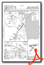
Nearby Airports with Instrument Procedures
| ID | Name | Heading / Distance | ||
|---|---|---|---|---|
 |
KNRB | Mayport Ns (Adm David L Mcdonald Field) Airport | 171° | 13.3 |
|
KJAX | Jacksonville International Airport | 239° | 13.7 |
|
KCRG | Jacksonville Exec At Craig Airport | 189° | 16.7 |
|
KNIP | Jacksonville NAS (Towers Field) Airport | 206° | 25.2 |
|
KHEG | Herlong Recreational Airport | 221° | 26.8 |
|
09J | Jekyll Island Airport | 003° | 27.7 |
|
KVQQ | Cecil Airport | 222° | 31.9 |
|
KSSI | St Simons Island Airport | 006° | 32.5 |
|
KBQK | Brunswick Golden Isles Airport | 359° | 38.7 |
|
KSGJ | Northeast Florida Regional Airport | 170° | 39.6 |
|
4J1 | Brantley County Airport | 327° | 42.3 |
|
42J | Keystone Heights Airport | 213° | 55.1 |
Airport Images
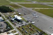
By: Brian Echard
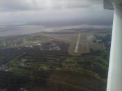
By: rettm5


Comments
Can't wait to come back
Very friendly people at this FBO. Let us use the crew car for two hours for no charge or fuel purchased.
Do not go to this FBO
The Bent Wing people are stealing from general aviation pilots under the guise of operating a terminal and some tie down spots. The terminal is locked up tight at 7pm. The after hours bathrooms were locked up. The person at the front desk took my credit card and information for my fuel payment and then after I left sent me an invoice for $66 dollars. I needed 3 gallons of fuel to top off. There were "no cars available" but when I left, on foot, at 7pm while they were closing, there was a car in the crew car space. Same car still there at 9am when I returned. Do not go to this FBO. Avoid the front desk at all costs. Go to the self serve. Go to a different airport. Save yourself.