Login
Register
FBL
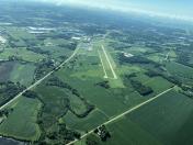
Faribault Municipal-Liz Wall Strohfus Field Airport
Official FAA Data Effective 2024-12-26 0901Z
VFR Chart of KFBL
Sectional Charts at SkyVector.com
IFR Chart of KFBL
Enroute Charts at SkyVector.com
Location Information for KFBL
Coordinates: N44°19.74' / W93°18.78'Located 03 miles NW of Faribault, Minnesota on 208 acres of land. View all Airports in Minnesota.
Surveyed Elevation is 1060 feet MSL.
Operations Data
|
|
Airport Communications
| AWOS-3: | 120.2 Tel. 507-332-2505 |
|---|---|
| MINNEAPOLIS APPROACH: | 134.7 284.7 |
| MINNEAPOLIS DEPARTURE: | 134.7 284.7 |
| AGUDE STAR: | 335.5 |
| CTAF: | 122.800 |
| UNICOM: | 122.800 |
| AWOS-3 at OWA (12.6 S): | 128.325 507-455-0642 |
| AWOS-3 at SYN (15.5 NE): | 119.35 507-664-3806 |
| AWOS-3 at LVN (18.2 N): | 118.0 952-469-5850 |
Nearby Navigation Aids
|
| ||||||||||||||||||||||||||||||||||||||||||||||||||||||
Runway 12/30
| Dimensions: | 4257 x 75 feet / 1298 x 23 meters | |
|---|---|---|
| Surface: | Asphalt in Fair Condition | |
| Weight Limits: | S-16, D-22 | |
| Edge Lighting: | Medium Intensity | |
| Runway 12 | Runway 30 | |
| Coordinates: | N44°19.89' / W93°19.09' | N44°19.47' / W93°18.31' |
| Elevation: | 1060.0 | 1048.4 |
| Traffic Pattern: | Left | Left |
| Runway Heading: | 127° True | 307° True |
| Displaced Threshold: | 230 Feet | |
| Markings: | Non-Precision Instrument in fair condition. | Non-Precision Instrument in fair condition. |
| Glide Slope Indicator | P4L (3.00° Glide Path Angle) RY 12 PAPI OPERATE CONTINUOUSLY. | P4L (3.00° Glide Path Angle) RY 30 PAPI OPERATE CONTINUOUSLY. |
| REIL: | Yes | Yes |
| Obstacles: | 37 ft Tree 263 ft from runway, 246 ft right of center RWY 12 HAS 20 FT TREE 120 FT FM THE RWY END AND 153 FT R. |
14 ft Road 580 ft from runway, 280 ft right of center RY 30 ROAD +14, 580 FM END, 280R, APCH SLOPE 57:1 FM DSPLCD THLD. |
Runway 01/19
| Dimensions: | 2300 x 175 feet / 701 x 53 meters | |
|---|---|---|
| Surface: | Turf in Fair Condition | |
| Runway 01 | Runway 19 | |
| Coordinates: | N44°19.67' / W93°18.99' | N44°20.04' / W93°18.90' |
| Elevation: | 1051.3 | 1054.6 |
| Runway Heading: | 10° True | 190° True |
| Markings: | Non-Standard in fair condition. | Non-Standard in fair condition. |
| Obstacles: | 78 ft Trees 1295 ft from runway, 221 ft left of center | |
Services Available
| Fuel: | 100LL (blue), Jet-A |
|---|---|
| Transient Storage: | Hangars,Tiedowns |
| Airframe Repair: | MAJOR |
| Engine Repair: | MAJOR |
| Bottled Oxygen: | LOW |
| Bulk Oxygen: | NONE |
| Other Services: | GLIDER SERVICE,PILOT INSTRUCTION,AIRCRAFT RENTAL,AIRCRAFT SALES |
Ownership Information
| Ownership: | Publicly owned | |
|---|---|---|
| Owner: | CITY OF FARIBAULT | |
| 208 1ST AVE, NW | ||
| FARIBAULT, MN 55021 | ||
| 507-334-2222 | ||
| Manager: | GERALD SERRES | |
| 3401 W TRUNK HWY 21 | ||
| FARIBAULT, MN 55021 | ||
| 507-332-0140 | ||
Other Remarks
- GCO AVBL ON FREQ 121.725 THRU MSP CD & FLT SVCS.
- ULTRALIGHTS & GLDRS USE TAXIWAY AND EXTENDED TAXIWAY PARALLEL TO RY 12/30. ULTRALIGHTS & GLDRS USING TAXIWAY FLY PATTERN ON 'NE' SIDE OF RY 12/30.
- WHEN LNDG ON RY 12, BE ALERT FOR TURBULENCE & POSS WINDSHEAR WHEN WINDS ARE OUT OF THE SOUTH.
- FOR CD CTC MINNEAPOLIS APCH AT 612-726-9086.
- RWY 01-19 NOT PLOWED WINTER MONTHS. OPEN FOR SKIPLANES.
- RY 01/19 MARKED WITH YELLOW CONES.
- 0LL SELF SVC FUEL WITH CREDIT CARD.
- MIRL RY 12/30 PRESET TO LOW; TO INCR INTST AND ACTVT REIL RY 12 & RY 30 - CTAF.
Weather Minimums
Standard Terminal Arrival (STAR) Charts
Instrument Approach Procedure (IAP) Charts
Nearby Airports with Instrument Procedures
| ID | Name | Heading / Distance | ||
|---|---|---|---|---|
 |
KOWA | Owatonna Degner Regional Airport | 169° | 12.6 |
 |
KLVN | Airlake Airport | 011° | 18.3 |
 |
KACQ | Waseca Municipal/Maynard Richard Stensrud Field Airport | 214° | 18.5 |
 |
KMKT | Mankato Regional Airport | 256° | 26.9 |
 |
KTOB | Dodge Center Airport | 131° | 27.9 |
 |
KFCM | Flying Cloud Airport | 348° | 30.6 |
 |
KMSP | Minneapolis-St Paul International/Wold-Chamberlain Airport | 006° | 33.4 |
 |
KSGS | South St Paul Municipal/Richard E Fleming Field Airport | 020° | 33.9 |
 |
KSTP | St Paul Downtown Holman Field Airport | 016° | 37.9 |
 |
KRGK | Red Wing Regional Airport | 066° | 38.9 |
 |
KAEL | Albert Lea Municipal Airport | 183° | 38.9 |
 |
KGYL | Glencoe Municipal Airport | 308° | 41.8 |


