Login
Register
EAR
Kearney Regional Airport
Official FAA Data Effective 2024-11-28 0901Z
VFR Chart of KEAR
Sectional Charts at SkyVector.com
IFR Chart of KEAR
Enroute Charts at SkyVector.com
Location Information for KEAR
Coordinates: N40°43.62' / W99°0.41'Located 04 miles NE of Kearney, Nebraska on 2500 acres of land. View all Airports in Nebraska.
Surveyed Elevation is 2131 feet MSL.
Operations Data
|
|
Airport Communications
| AWOS-3PT: | 123.875 Tel. 308-237-5608 |
|---|---|
| UNICOM: | 123.000 |
| CTAF: | 123.000 |
| AWOS-3 at HDE (22.4 SW): | 121.325 308-995-6433 |
| ASOS at HSI (27.4 E): | 120.525 402-463-4029 |
| ATIS at GRI (34.8 NE): | 127.4 |
- APCH/DEP SVC PRVDD BY MINNEAPOLIS ARTCC ON FREQS 119.4/278.8 (HASTINGS RCAG).
Nearby Navigation Aids
|
| ||||||||||||||||||||||||||||||||||||||||||||||||||||||||||||
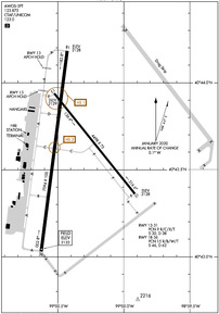
Runway 18/36
| Dimensions: | 7094 x 100 feet / 2162 x 30 meters | |
|---|---|---|
| Surface: | Concrete in Excellent Condition | |
| Weight Limits: | 15 /R/B/W/T, S-46, D-62 | |
| Edge Lighting: | High Intensity | |
| Runway 18 | Runway 36 | |
| Coordinates: | N40°44.18' / W99°0.43' | N40°43.03' / W99°0.62' |
| Elevation: | 2127.8 | 2131.6 |
| Traffic Pattern: | Left | Left |
| Runway Heading: | 187° True | 7° True |
| Declared Distances: | TORA:7094 TODA:7094 ASDA:7094 LDA:7094 | TORA:7094 TODA:7094 ASDA:7094 LDA:7094 |
| Markings: | Non-Precision Instrument in good condition. | Precision Instrument in good condition. |
| Glide Slope Indicator | P4L (3.00° Glide Path Angle) | P4L (3.00° Glide Path Angle) |
| Approach Lights: | MALSR 1,400 Foot Medium-intensity Approach Lighting System with runway alignment indicator lights. | |
| REIL: | Yes | |
| Obstacles: | 103 ft Building 5250 ft from runway | |
Runway 13/31
| Dimensions: | 4498 x 75 feet / 1371 x 23 meters | |
|---|---|---|
| Surface: | Concrete in Excellent Condition | |
| Weight Limits: | 9 /R/C/X/T, S-30, D-38 | |
| Edge Lighting: | Medium Intensity | |
| Runway 13 | Runway 31 | |
| Coordinates: | N40°43.94' / W99°0.52' | N40°43.36' / W98°59.91' |
| Elevation: | 2129.2 | 2128.4 |
| Traffic Pattern: | Left | Left |
| Runway Heading: | 141° True | 321° True |
| Declared Distances: | TORA:4498 TODA:4498 ASDA:4498 LDA:4498 | TORA:4498 TODA:4498 ASDA:4498 LDA:4498 |
| Markings: | Non-Precision Instrument in good condition. | Non-Precision Instrument in good condition. |
| Glide Slope Indicator | P2L (3.00° Glide Path Angle) | P2L (3.00° Glide Path Angle) |
Services Available
| Fuel: | 100LL (blue), Jet-A |
|---|---|
| Transient Storage: | Hangars,Tiedowns |
| Airframe Repair: | MAJOR |
| Engine Repair: | MAJOR |
| Bottled Oxygen: | NONE |
| Bulk Oxygen: | NONE |
| Other Services: | AIR FREIGHT SERVICES,CROP DUSTING SERVICES,AIR AMBULANCE SERVICES,CHARTER SERVICE,PILOT INSTRUCTION,AIRCRAFT RENTAL,AIRCRAFT SALES |
Ownership Information
| Ownership: | Publicly owned | |
|---|---|---|
| Owner: | CITY OF KEARNEY | |
| P.O. BOX 1180 | ||
| KEARNEY, NE 68848 | ||
| 308-233-3212 | ||
| Manager: | JAMES LYNAUGH | |
| P.O. BOX 1180 | ||
| KEARNEY, NE 68848 | ||
| 308-234-2318 | ||
Other Remarks
- BE ALERT WHEN TAXIING ON APRON DUE TO SEVERAL CLOSED AREAS.
- AIR CARRIER OPS ARE NOT AUTHORIZED IN EXCESS OF 15 MINUTES BEFORE OR AFTER SCHEDULED ARRIVAL/DEPARTURE TIMES WITHOUT PRIOR COORDINATION WITH AMGR AND CONFIRMATION THAT ARFF IS AVBL PRIOR TO LDNG OR TKOF.
- FOR CD IF UNA TO CTC ON FSS FREQ, CTC MINNEAPOLIS ARTCC AT 651-463-5588.
- HIRL RWY 18/36 PRESET ON LOW INTST; TO INCR INTST & ACTVT REIL RWY 18; MALSR RWY 36; PAPI RWYS 13, 18, 31, & 36; AND MIRL RWY 13/31 - CTAF.
Weather Minimums
Instrument Approach Procedure (IAP) Charts
Nearby Airports with Instrument Procedures
| ID | Name | Heading / Distance | ||
|---|---|---|---|---|
 |
0V3 | Pioneer Village Field Airport | 167° | 13.0 |
 |
KHDE | Brewster Field Airport | 222° | 22.3 |
 |
KHSI | Hastings Municipal Airport | 105° | 27.4 |
 |
0F4 | Loup City Municipal Airport | 001° | 33.5 |
 |
KGRI | Central Nebraska Regional Airport | 065° | 34.9 |
 |
KLXN | Jim Kelly Field Airport | 276° | 35.3 |
 |
4D9 | Alma Municipal Airport | 203° | 40.0 |
 |
08K | Harvard State Airport | 095° | 42.5 |
 |
7V7 | Red Cloud Municipal Airport | 150° | 44.2 |
 |
KCZD | Cozad Municipal Airport | 280° | 46.2 |
 |
KAUH | Aurora Municipal/Al Potter Field Airport | 077° | 47.2 |
 |
07K | Central City Municipal/Larry Reineke Field Airport | 061° | 49.2 |


