Login
Register
ARR
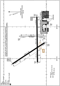
Aurora Municipal Airport
Official FAA Data Effective 2024-11-28 0901Z
From the Flight Deck
VFR Chart of KARR
Sectional Charts at SkyVector.com
IFR Chart of KARR
Enroute Charts at SkyVector.com
Location Information for KARR
Coordinates: N41°46.32' / W88°28.54'Located 38 miles W of Chicago/Aurora, Illinois on 1100 acres of land. View all Airports in Illinois.
Surveyed Elevation is 712 feet MSL.
Operations Data
|
|
Airport Communications
| ATIS: | 125.85 |
|---|---|
| ASOS: | Tel. 630-466-5649 |
| AURORA TOWER: | 120.6 |
| AURORA GROUND: | 121.7 |
| CHICAGO APPROACH: | 133.5 349.0 |
| CHICAGO DEPARTURE: | 133.5 349.0 |
| CLEARANCE DELIVERY: | 121.7 ;WHEN AURORA TWR CLSD |
| CTAF: | 120.600 |
| UNICOM: | 122.950 |
| ASOS at DPA (13.0 NE): | 630-587-3668 |
| ATIS at DPA (13.0 NE): | 132.075 |
| AWOS-3 at DKB (14.2 NW): | 119.075 815-748-2350 |
- EMERG FREQ 121.5 NOT AVBL AT TWR.
Nearby Navigation Aids
|
| ||||||||||||||||||||||||||||||||||||||||||||||||||||||
Runway 09/27
| Dimensions: | 6501 x 100 feet / 1982 x 30 meters | |
|---|---|---|
| Surface: | Concrete / Grooved in Good Condition | |
| Weight Limits: | S-30, D-130 | |
| Edge Lighting: | High Intensity | |
| Runway 09 | Runway 27 | |
| Coordinates: | N41°46.21' / W88°29.12' | N41°46.23' / W88°27.69' |
| Elevation: | 706.8 | 707.2 |
| Traffic Pattern: | Left | |
| Runway Heading: | 89° True | 269° True |
| Declared Distances: | ASDA:6972 | ASDA:6460 LDA:6460 |
| Markings: | Precision Instrument in good condition. | Precision Instrument in good condition. |
| Glide Slope Indicator | P4L (3.00° Glide Path Angle) | P4L (3.00° Glide Path Angle) |
| Approach Lights: | MALSR 1,400 Foot Medium-intensity Approach Lighting System with runway alignment indicator lights. | |
| REIL: | Yes | |
Runway 15/33
| Dimensions: | 5503 x 100 feet / 1677 x 30 meters | |
|---|---|---|
| Surface: | Concrete / Grooved in Good Condition | |
| Weight Limits: | D-130 | |
| Edge Lighting: | High Intensity | |
| Runway 15 | Runway 33 | |
| Coordinates: | N41°46.80' / W88°29.17' | N41°46.04' / W88°28.50' |
| Elevation: | 712.0 | 698.5 |
| Runway Heading: | 147° True | 327° True |
| Markings: | Precision Instrument in good condition. | Precision Instrument in good condition. |
| Glide Slope Indicator | P4L (3.00° Glide Path Angle) | P4L (3.00° Glide Path Angle) |
| Approach Lights: | MALSR 1,400 Foot Medium-intensity Approach Lighting System with runway alignment indicator lights. | |
| REIL: | Yes | |
| Obstacles: | 44 ft Tree 1039 ft from runway, 540 ft left of center | 88 ft Tree 3503 ft from runway, 924 ft left of center |
Runway 18/36
| Dimensions: | 3198 x 75 feet / 975 x 23 meters | |
|---|---|---|
| Surface: | Asphalt in Poor Condition SEVERAL LARGE CRACKS & VEGETATIVE GROWTH. | |
| Weight Limits: | S-30 | |
| Edge Lighting: | Medium Intensity | |
| Runway 18 | Runway 36 | |
| Coordinates: | N41°46.59' / W88°28.30' | N41°46.07' / W88°28.30' |
| Elevation: | 700.1 | 700.4 |
| Traffic Pattern: | Left | |
| Runway Heading: | 180° True | 360° True |
| Markings: | Basic in fair condition. | Non-Precision Instrument in fair condition. |
| Glide Slope Indicator | P4L (3.00° Glide Path Angle) | V4L (3.00° Glide Path Angle) |
| REIL: | Yes | Yes |
| Obstacles: | 39 ft Pole 1129 ft from runway, 296 ft right of center RISING GROUND +6 FEET. |
73 ft Tree 3140 ft from runway, 497 ft right of center |
Services Available
| Fuel: | 100 (green), Jet A-1 |
|---|---|
| Transient Storage: | Hangars,Tiedowns |
| Airframe Repair: | MAJOR |
| Engine Repair: | MAJOR |
| Bottled Oxygen: | HIGH/LOW |
| Bulk Oxygen: | HIGH/LOW |
| Other Services: | AIR FREIGHT SERVICES,AVIONICS,CARGO HANDLING SERVICES,CHARTER SERVICE,PILOT INSTRUCTION,AIRCRAFT RENTAL,AIRCRAFT SALES |
Ownership Information
| Ownership: | Publicly owned | |
|---|---|---|
| Owner: | CITY OF AURORA | |
| 44 E. DOWNER PLACE | ||
| AURORA, IL 60507 | ||
| (630) 256-3120 | ||
| Manager: | STEVE ANDRAS | |
| 43W 636 US30 | ||
| SUGAR GROVE, IL 60554 | ||
| (630) 256-3120 | ||
Other Remarks
- SEASONAL CROPS IN PART 77 SURFACES RUNWAY 9/27 & 15/33
- ACTVT MALSR RWY 09, 33; REIL RWY 18, 36,15, 27; TWY LGTS - CTAF. WHEN ATCT CLSD HIRL RWY 15/33, 09/27; MIRL RWY 18/36 PRESET LOW INTST, TO INCR INTST & ACTVT - CTAF.
- ADDNL UNICOM FREQ IS 123.50.
Weather Minimums
Instrument Approach Procedure (IAP) Charts
Departure Procedure (DP) Charts
Nearby Airports with Instrument Procedures
| ID | Name | Heading / Distance | ||
|---|---|---|---|---|
 |
KDPA | Dupage Airport | 051° | 13.0 |
 |
KDKB | De Kalb Taylor Municipal Airport | 313° | 14.2 |
 |
1C5 | Bolingbrook's Clow International Airport | 106° | 16.2 |
 |
KLOT | Lewis University Airport | 119° | 19.7 |
 |
C09 | Morris Municipal/James R Washburn Field Airport | 172° | 21.0 |
 |
3CK | Lake In The Hills Airport | 014° | 27.0 |
 |
KRPJ | Rochelle Municipal/Koritz Field Airport | 285° | 28.0 |
 |
KORD | Chicago O'Hare International Airport | 064° | 28.3 |
 |
KMDW | Chicago Midway International Airport | 088° | 32.5 |
 |
KPWK | Chicago Exec Airport | 051° | 32.9 |
 |
C77 | Poplar Grove Airport | 334° | 36.8 |
 |
KRFD | Chicago/Rockford International Airport | 312° | 37.7 |


