Login
Register
LBF
North Platte Regional/Lee Bird Field Airport
Official FAA Data Effective 2024-10-31 0901Z
VFR Chart of KLBF
Sectional Charts at SkyVector.com
IFR Chart of KLBF
Enroute Charts at SkyVector.com
Location Information for KLBF
Coordinates: N41°7.57' / W100°41.02'Located 03 miles E of North Platte, Nebraska on 1544 acres of land. View all Airports in Nebraska.
Surveyed Elevation is 2777 feet MSL.
ALL CAT D ACFT (WITH SPDS OF 141-166 KTS) OPERATING ON RWY 12/30 MUST MNTN A TPA OF 1500 FT WHEN IN THE TFC PAT.
Operations Data
|
|
Airport Communications
| ASOS: | 118.425 Tel. 308-534-1617 |
|---|---|
| UNICOM: | 123.000 |
| CTAF: | 123.000 |
| AWOS-3 at LXN (45.8 SE): | 121.025 308-324-5975 |
| AWOS-3 at OGA (49.1 W): | 121.275 308-284-6573 |
| AWOS-3PT at GGF (49.9 W): | 118.025 308-352-4689 |
- APCH/DEP CTL SVC PRVDD BY DENVER ARTCC (ZDV) ON FREQS 132.7/226.675 (NORTH PLATTE RCAG).
- CLEARANCE DELIVERY PRVDD BY DENVER ARTCC ON FREQ 132.7.
Nearby Navigation Aids
|
| ||||||||||||||||||||||||||||||||||||||||||||||||||||||||||||
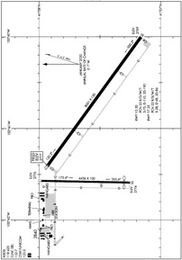
Runway 12/30
| Dimensions: | 8001 x 150 feet / 2439 x 46 meters | |
|---|---|---|
| Surface: | Concrete / Grooved in Excellent Condition | |
| Weight Limits: | 33 /R/D/W/T, S-75, D-110, ST-190 | |
| Edge Lighting: | High Intensity | |
| Runway 12 | Runway 30 | |
| Coordinates: | N41°7.93' / W100°41.41' | N41°7.16' / W100°40.00' |
| Elevation: | 2777.0 | 2769.0 |
| Traffic Pattern: | Left | Left |
| Runway Heading: | 126° True | 306° True |
| Declared Distances: | TORA:8001 TODA:8001 ASDA:8001 LDA:8001 | TORA:8001 TODA:8001 ASDA:8001 LDA:8001 |
| Markings: | Precision Instrument in good condition. | Precision Instrument in good condition. |
| Glide Slope Indicator | P4L (3.00° Glide Path Angle) | P4L (3.00° Glide Path Angle) |
| Approach Lights: | MALSR 1,400 Foot Medium-intensity Approach Lighting System with runway alignment indicator lights. | |
Runway 17/35
| Dimensions: | 4436 x 100 feet / 1352 x 30 meters | |
|---|---|---|
| Surface: | Concrete in Excellent Condition | |
| Weight Limits: | 22 /R/B/W/T, S-28, D-48, ST-86 | |
| Edge Lighting: | Medium Intensity | |
| Runway 17 | Runway 35 | |
| Coordinates: | N41°7.98' / W100°41.57' | N41°7.25' / W100°41.59' |
| Elevation: | 2775.7 | 2774.1 |
| Traffic Pattern: | Left | Left |
| Runway Heading: | 181° True | 1° True |
| Displaced Threshold: | 301 Feet | |
| Declared Distances: | TORA:4436 TODA:4436 ASDA:4135 LDA:4135 | TORA:4436 TODA:4436 ASDA:4436 LDA:4135 |
| Markings: | Non-Precision Instrument in good condition. | Non-Precision Instrument in good condition. |
| Glide Slope Indicator | V4L (3.00° Glide Path Angle) | |
| REIL: | Yes | |
| Obstacles: | 21 ft Road 850 ft from runway | 27 ft Tree 675 ft from runway, 150 ft left of center RWY 35 APCH RATIO 36:1 TO DSPLCD THLD. |
Services Available
| Fuel: | 100LL (blue), Jet-A |
|---|---|
| Transient Storage: | Hangars,Tiedowns |
| Airframe Repair: | MAJOR |
| Engine Repair: | MAJOR |
| Bottled Oxygen: | HIGH/LOW |
| Bulk Oxygen: | LOW |
| Other Services: | AIR FREIGHT SERVICES,CHARTER SERVICE,PILOT INSTRUCTION,AIRCRAFT RENTAL |
Ownership Information
| Ownership: | Publicly owned | |
|---|---|---|
| Owner: | NORTH PLATTE AIRPORT AUTH | |
| PO BOX 1517 | ||
| NORTH PLATTE, NE 69103 | ||
| 308-532-1900 | ||
| Manager: | MR. SAM SEAFELDT | |
| 5400 E LEE BIRD DR | ||
| NORTH PLATTE, NE 69101 | ||
| (308) 530-0607 | AFT HRS EMERG, CALL OPNS SUPVR 308-530-6948. | |
Other Remarks
- WATERFOWL ON & INVOF ARPT.
- FOR CD CTC DENVER ARTCC ON FREQ. IF UNA, CTC FSS ON FREQ VIA RCO. IF UNA, CTC DENVER ARTCC AT 303-651-4257.
- ACTVT HIRL RWY 12/30; MIRL RWY 17/35; PAPI RWY 12 & 30; VASI RWY 35; MALSR RWY 30 & REIL RWY 35 - CTAF.
- ALL CAT D ACFT (WITH SPDS OF 141-166 KTS) OPERATING ON RWY 12/30 MUST MNTN A TPA OF 1500 FT WHEN IN THE TFC PAT.
Weather Minimums
Instrument Approach Procedure (IAP) Charts
Nearby Airports with Instrument Procedures
| ID | Name | Heading / Distance | ||
|---|---|---|---|---|
 |
KGTE | Gothenburg Municipal Airport | 116° | 27.2 |
 |
47V | Curtis Municipal Airport | 161° | 30.8 |
 |
KCZD | Cozad Municipal Airport | 116° | 34.5 |
 |
KLXN | Jim Kelly Field Airport | 115° | 45.9 |
 |
KOGA | Searle Field Airport | 269° | 49.2 |
 |
KGGF | Grant Municipal Airport | 252° | 50.1 |
 |
KTIF | Thomas County Airport | 005° | 50.4 |
 |
KBBW | Broken Bow Municipal/Keith Glaze Field Airport | 068° | 50.7 |
 |
KCSB | Cambridge Municipal Airport | 153° | 54.6 |
 |
KMCK | Mc Cook Ben Nelson Regional Airport | 175° | 55.3 |
 |
KIML | Imperial Municipal Airport | 229° | 56.4 |
 |
KHDE | Brewster Field Airport | 122° | 73.5 |


