Login
Register
RDU
Raleigh-Durham International Airport
Official FAA Data Effective 2024-12-26 0901Z
VFR Chart of KRDU
Sectional Charts at SkyVector.com
IFR Chart of KRDU
Enroute Charts at SkyVector.com
Location Information for KRDU
Coordinates: N35°52.66' / W78°47.25'Located 09 miles NW of Raleigh/Durham, North Carolina on 5000 acres of land. View all Airports in North Carolina.
Surveyed Elevation is 435 feet MSL.
Operations Data
|
|
Airport Communications
| D-ATIS: | 123.8 (919-840-0486) |
|---|---|
| ASOS: | Tel. 919-840-0816 |
| RALEIGH TOWER: | 127.45 257.8 |
| RALEIGH GROUND: | 121.9 348.6 |
| RALEIGH APPROACH: | 124.95 ;055-229 127.675 ;230-054 307.9 ;230-054 318.2 ;055-229 |
| RALEIGH DEPARTURE: | 125.3 ;055-229 132.35 ;230-054 256.9 ;230-054 353.675 ;055-229 353.675 ;SOUTH |
| IC: | 127.675 ;230-054 307.9 ;230-054 |
| CLEARANCE DELIVERY: | 120.1 |
| OXFRD DP: | 132.35 256.9 |
| DMSTR STAR: | 127.675 307.9 |
| ROZBO DP: | 125.3 353.675 |
| EMERG: | 121.5 |
| HOOKZ DP: | 125.3 353.675 |
| TAQLE STAR: | 124.95 318.2 |
| BEXGO DP: | 132.35 256.9 |
| SHPRD DP: | 132.35 256.9 |
| RALEIGH DP: | 125.3 ;055-229 132.35 ;230-054 256.9 ;230-054 353.675 ;055-229 |
| UNICOM: | 122.950 |
| FINAL: | 285.425 ;EAST |
| CLASS C: | 125.3 ;055-229 132.35 ;230-054 256.9 ;230-054 353.675 ;055-229 |
| BLOGS STAR: | 124.95 318.2 |
| HURIC DP: | 125.3 353.675 |
| BRADE STAR: | 124.95 318.2 |
| LWOOD DP: | 132.35 256.9 |
| BUZZY STAR: | 127.675 307.9 |
| PACKK DP: | 125.3 ;055-229 132.35 ;230-054 256.9 ;230-054 353.675 ;055-229 |
| AWOS-3 at TQV (10.7 NW): | 121.325 |
| AWOS-3 at LHZ (23.7 E): | 118.325 919-497-0810 |
| AWOS-3 at TTA (23.8 SW): | 120.625 919-708-5382 |
Nearby Navigation Aids
|
| ||||||||||||||||||||||||||||||||||||||||||||||||||||||||||||
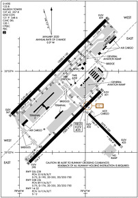
Runway 05L/23R
RWY 05L/23R UNGROOVED. | ||
| Dimensions: | 10000 x 150 feet / 3048 x 46 meters | |
|---|---|---|
| Surface: | Concrete / Wire Combed in Good Condition | |
| Weight Limits: | 33 /R/B/X/T, S-75, D-190, ST-355, DT-750 | |
| Edge Lighting: | High Intensity | |
| Runway 05L | Runway 23R | |
| Coordinates: | N35°52.47' / W78°48.12' | N35°53.63' / W78°46.68' |
| Elevation: | 366.8 | 408.6 |
| Traffic Pattern: | Right | |
| Runway Heading: | 45° True | 225° True |
| Declared Distances: | TORA:10000 TODA:10000 ASDA:10000 LDA:10000 | TORA:10000 TODA:10000 ASDA:10000 LDA:10000 |
| Markings: | Precision Instrument in good condition. | Precision Instrument in good condition. |
| Glide Slope Indicator | P4L (3.00° Glide Path Angle) | P4L (3.00° Glide Path Angle) |
| RVR Equipment | Touchdown Midfield Rollout | Touchdown Midfield Rollout |
| Approach Lights: | MALSR 1,400 Foot Medium-intensity Approach Lighting System with runway alignment indicator lights. | ALSF2 Standard 2,400 Foot High-intensity Approach Lighting System with sequenced flashers, CATEGORY II or III Configuration. |
| Centerline Lights: | Yes | Yes |
Runway 05R/23L
| Dimensions: | 7500 x 150 feet / 2286 x 46 meters | |
|---|---|---|
| Surface: | Asphalt / Grooved in Good Condition | |
| Weight Limits: | 89 /F/A/X/T, S-75, D-176, ST-335, DT-750 | |
| Edge Lighting: | High Intensity | |
| Runway 05R | Runway 23L | |
| Coordinates: | N35°51.88' / W78°47.84' | N35°52.75' / W78°46.76' |
| Elevation: | 397.5 | 430.7 |
| Traffic Pattern: | Right | |
| Runway Heading: | 45° True | 225° True |
| Declared Distances: | TORA:7500 TODA:7500 ASDA:7500 LDA:7500 | TORA:7500 TODA:7500 ASDA:7500 LDA:7500 |
| Markings: | Precision Instrument in good condition. | Precision Instrument in good condition. |
| Glide Slope Indicator | P4L (3.00° Glide Path Angle) | P4L (3.00° Glide Path Angle) |
| RVR Equipment | Touchdown Rollout | Touchdown Rollout |
| Approach Lights: | MALSR 1,400 Foot Medium-intensity Approach Lighting System with runway alignment indicator lights. | MALSR 1,400 Foot Medium-intensity Approach Lighting System with runway alignment indicator lights. |
| Centerline Lights: | Yes | Yes |
Runway 14/32
| Dimensions: | 3570 x 100 feet / 1088 x 30 meters | |
|---|---|---|
| Surface: | Asphalt in Good Condition | |
| Weight Limits: | 16 /F/A/X/T, S-12 | |
| Edge Lighting: | Medium Intensity | |
| Runway 14 | Runway 32 | |
| Coordinates: | N35°52.50' / W78°46.96' | N35°52.08' / W78°46.45' |
| Elevation: | 432.1 | 424.7 |
| Traffic Pattern: | Left | Left |
| Runway Heading: | 135° True | 315° True |
| Markings: | Non-Precision Instrument in good condition. | Non-Precision Instrument in good condition. |
| Glide Slope Indicator | P4L (3.50° Glide Path Angle) | |
| REIL: | Yes | |
| Obstacles: | 120 ft Trees 3046 ft from runway, 1 ft left of center | |
Services Available
| Fuel: | 100LL (blue), Jet-A |
|---|---|
| Transient Storage: | Hangars,Tiedowns |
| Airframe Repair: | MAJOR |
| Engine Repair: | MAJOR |
| Bottled Oxygen: | NONE |
| Bulk Oxygen: | HIGH/LOW |
| Other Services: | AIR FREIGHT SERVICES,AIR AMBULANCE SERVICES,AVIONICS,CARGO HANDLING SERVICES,CHARTER SERVICE,PILOT INSTRUCTION,AIRCRAFT RENTAL,AIRCRAFT SALES,ANNUAL SURVEYING |
Ownership Information
| Ownership: | Publicly owned | |
|---|---|---|
| Owner: | RALEIGH-DURHAM ARPT AUTH | |
| P.O. BOX 80001 | ||
| RDU AIRPORT, NC 27623 | ||
| 919-840-7700 | ||
| Manager: | MICHAEL LANDGUTH | |
| RALEIGH-DURHAM ARPT AUTH, P.O. BOX 80001 | ||
| RDU AIRPORT, NC 27623 | ||
| (919) 840-7701 | ||
Other Remarks
- NO JET ENGINE MAINTENANCE RUNS BETWEEN 0000-0600.
- RSTD: PPR FOR ALL MILITARY AIRCRAFT F/W - R/W & UNSCHEDULED CHARTER FLIGHTS WITH 30 OR MORE PASSENGERS. 24 HR PN RQR FOR MIL PRACTICE APCH. CTC ARPT OPS 919-840-7510 OR RDU APP C919-380-3125. 24 HR PN RQR FOR PPR FOR ALL F/W AND R/W MIL ACFT GOING TO ARNG RAMP, POC C984-661-6200. OSACOM FLT DET C984-661-6202.
- ARPT CLSD TO AIRSHIPS.
- TWY E BEHIND SOUTH CARGO 4 & TWY J BEHIND CORPORATE HANGARS NOT VSBL FM ATCT.
- ARNG: LTD PRK. ARNG OPS C984-661-6200. CTC FORECAST BASE 10 MIN PRIOR LDG. RAMP CLSD TO ALL F/W EXCEPT ARMY & MIL TRANSPORT WITH PPR, FACILITY HRS 1300-2130Z++ MON-FRI EXC HOL. MAKE APPT FOR AFTER DUTY HRS. OSACOM FLT DET C984-661-6202.
- TWY F5 IS CLSD UFN.
- ALL TDG V AIRCRAFT TXG ON TWY A ARE RSTD TO TAXI SPD OF 15 MPH.
- APN TXL F BTN TWY T1 AND TWY T7 CLSD TO ACFT WITH WINGSPAN MORE THAN 171 FT.
- NG PPR FOR LDG CTC V582-9181 C(919)664-9181.
- TWY D CLSD TO ACFT WITH WINGSPAN MORE THAN 171 FT WHEN TWY G AND H ARE OCCUPIED.
- TRML 1 ACFT MUST CTC ATC ON 121.9 PRIOR TO PUSH ONTO TWY A. TRML 2 ACFT MUST CTC RAMP TWR ON 130.175 PRIOR TO PUSH. NORTH CARGO APRON ADG IV OR V ACFT MUST CTC ATC ON 121.9 PRIOR TO PUSH.
- TWY C BTN TWY F AND G IS RSTRD TO ACFT LESS THAN A MAX GROSS TKOF WEIGHT OF 490000 LBS.
- NG 24 HR PPR FOR JET ACFT & TRANS MIL ACFT - 919-840-7510.
Weather Minimums
Standard Terminal Arrival (STAR) Charts
Instrument Approach Procedure (IAP) Charts
- ILS OR LOC RWY 05L

- ILS OR LOC RWY 05R

- ILS OR LOC RWY 23L

- ILS OR LOC RWY 23R

- ILS RWY 05R (SA CAT I - II)

- ILS RWY 23R (CAT II - III)

- RNAV (RNP) Z RWY 05L

- RNAV (RNP) Z RWY 05R

- RNAV (RNP) Z RWY 23L

- RNAV (RNP) Z RWY 23R

- RNAV (GPS) RWY 32

- RNAV (GPS) Y RWY 05L

- RNAV (GPS) Y RWY 05R

- RNAV (GPS) Y RWY 23L

- RNAV (GPS) Y RWY 23R

Departure Procedure (DP) Charts
Nearby Airports with Instrument Procedures
| ID | Name | Heading / Distance | ||
|---|---|---|---|---|
 |
KTTA | Raleigh Exec Jetport At Sanford-Lee County Airport | 221° | 23.4 |
 |
KLHZ | Triangle North Exec Airport | 068° | 23.9 |
 |
KTDF | Raleigh Regional At Person County Airport | 338° | 26.2 |
 |
KJNX | Johnston Regional Airport | 135° | 28.0 |
 |
KHRJ | Harnett Regional Jetport Airport | 174° | 29.9 |
 |
KHNZ | Henderson/Oxford Airport | 023° | 31.6 |
 |
KBUY | Burlington/Alamance Regional Airport | 287° | 34.9 |
 |
KSCR | Siler City Municipal Airport | 253° | 36.5 |
 |
W03 | Wilson Industrial Air Center Airport | 098° | 40.4 |
 |
KRWI | Rocky Mount/Wilson Regional Airport | 091° | 43.7 |
 |
KPOB | Pope AAF Airport | 194° | 43.8 |
 |
W63 | Lake Country Regional Airport | 014° | 44.5 |


