Login
Register
GKY
Arlington Municipal Airport
Official FAA Data Effective 2024-12-26 0901Z
VFR Chart of KGKY
Sectional Charts at SkyVector.com
IFR Chart of KGKY
Enroute Charts at SkyVector.com
Location Information for KGKY
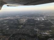
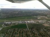
Coordinates: N32°39.83' / W97°5.66'Located 04 miles S of Arlington, Texas on 500 acres of land. View all Airports in Texas.
Surveyed Elevation is 628 feet MSL.
Operations Data
|
|
Airport Communications
| ASOS: | 127.375 Tel. 817-557-0251 |
|---|---|
| ARLINGTON TOWER: | 128.625 |
| ARLINGTON GROUND: | 121.875 |
| LONE STAR APPROACH: | 135.975 379.9 |
| LONE STAR DEPARTURE: | 135.975 379.9 |
| CLEARANCE DELIVERY: | 121.875 118.85 ;WHEN GKY TWR CLSD |
| DALLAS AREA DP: | 135.975 379.9 |
| WESAT STAR: | 118.1 ;SOUTH 125.8 ;NORTH 306.95 |
| TRUUK RNAV STAR: | 118.1 306.95 |
| CTAF: | 128.625 |
| SASIE STAR: | 124.3 282.275 |
| LIKES STAR: | 125.8 ;SOUTH 135.975 ;NORTH 257.95 |
| DODJE STAR: | 125.2 125.9 343.65 |
| NANDR RNAV DP: | 135.975 379.9 |
| MOTZA STAR: | 118.1 ;SOUTH 125.8 ;NORTH 306.95 |
| GARLAND DP: | 135.975 379.9 |
| REEKO STAR: | 125.2 343.65 |
| SWVAY STAR: | 135.975 379.9 |
| JOE POOL DP: | 135.975 379.9 |
| AWOS-3P at GPM (3.2 NE): | 118.475 972-606-1433 |
| ATIS at RBD (11.4 E): | 126.35 |
| ASOS at RBD (11.5 E): | 214-330-5317 |
Nearby Navigation Aids
|
| ||||||||||||||||||||||||||||||||||||||||||||||||||||||||||||
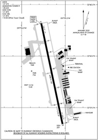
Runway 16/34
| Dimensions: | 6080 x 100 feet / 1853 x 30 meters | |
|---|---|---|
| Surface: | Concrete in Good Condition | |
| Weight Limits: | S-60 | |
| Edge Lighting: | Medium Intensity | |
| Runway 16 | Runway 34 | |
| Coordinates: | N32°40.32' / W97°5.78' | N32°39.34' / W97°5.53' |
| Elevation: | 628.2 | 596.9 |
| Traffic Pattern: | Left | Left |
| Runway Heading: | 168° True | 348° True |
| Markings: | Non-Precision Instrument in good condition. | Precision Instrument in good condition. |
| Glide Slope Indicator | P4L (3.00° Glide Path Angle) | P4L (3.00° Glide Path Angle) |
| Approach Lights: | MALSR 1,400 Foot Medium-intensity Approach Lighting System with runway alignment indicator lights. | |
| REIL: | Yes | |
Services Available
| Fuel: | 100LL (blue), Jet-A |
|---|---|
| Transient Storage: | Hangars,Tiedowns |
| Airframe Repair: | MAJOR |
| Engine Repair: | MAJOR |
| Bottled Oxygen: | LOW |
| Bulk Oxygen: | NONE |
| Other Services: | AVIONICS,PILOT INSTRUCTION,AIRCRAFT RENTAL,AIRCRAFT SALES |
Ownership Information
| Ownership: | Publicly owned | |
|---|---|---|
| Owner: | CITY OF ARLINGTON | |
| PO BOX 90231 | ||
| ARLINGTON, TX 76004-3231 | ||
| 817-459-5571 | ||
| Manager: | TRENT BALLARD | |
| 5000 S. COLLINS, STE 100 | ||
| ARLINGTON, TX 76018-3231 | ||
| 817-459-5571 | ||
Other Remarks
- THIS AIRPORT HAS BEEN SURVEYED BY THE NATIONAL GEODETIC SURVEY.
- EXTSV HEL TFC WEST OF RWY.
- 0LL 100LL SELF SERVE FUEL.
- MIRL RWY 16/34 PRESET MED INTST; HIGHER INTST BY ATCT REQ. WHEN ATCT CLSD ACTVT MALSR RWY 34 - CTAF.
Weather Minimums
Standard Terminal Arrival (STAR) Charts
Instrument Approach Procedure (IAP) Charts
Departure Procedure (DP) Charts
- DALLAS THREE

- DALLAS THREE, CONT.1

- GARLAND FIVE

- GARLAND FIVE, CONT.1

- JOE POOL SEVEN

- JOE POOL SEVEN, CONT.1

- KINGDOM FOUR

- KINGDOM FOUR, CONT.1

- KUSSO ONE (RNAV)

- KUSSO ONE (RNAV), CONT.1

- NANDR TWO (RNAV)

- NANDR TWO (RNAV), CONT.1

- SWABR ONE (RNAV)

- SWABR ONE (RNAV), CONT.1

- TEXOMA FIVE

- TEXOMA FIVE, CONT.1

- WORTH ONE

- WORTH ONE, CONT.1

Nearby Airports with Instrument Procedures
| ID | Name | Heading / Distance | ||
|---|---|---|---|---|
 |
KGPM | Grand Prairie Municipal Airport | 048° | 3.2 |
 |
KRBD | Dallas Exec Airport | 084° | 11.5 |
 |
KFWS | Fort Worth Spinks Airport | 241° | 12.4 |
 |
KDFW | Dallas-Fort Worth International Airport | 011° | 14.3 |
 |
KJWY | Mid-Way Regional Airport | 143° | 15.4 |
 |
KDAL | Dallas Love Field Airport | 048° | 16.4 |
 |
KFTW | Fort Worth Meacham International Airport | 304° | 16.5 |
 |
KNFW | Fort Worth NAS Jrb (Carswell Field) Airport | 289° | 18.7 |
 |
KLNC | Lancaster Regional Airport | 105° | 19.8 |
 |
KADS | Addison Airport | 035° | 22.4 |
 |
KAFW | Perot Field/Fort Worth Alliance Airport | 329° | 22.6 |
 |
KCPT | Cleburne Regional Airport | 222° | 25.3 |


